



Airborne Terminal · SkyEye (YunScan-Air)
Product Positioning
Airborne RemoteID Detection Device. Mounted on UAVs for aerial detection, it overcomes ground obstructions and enables large-area scanning.
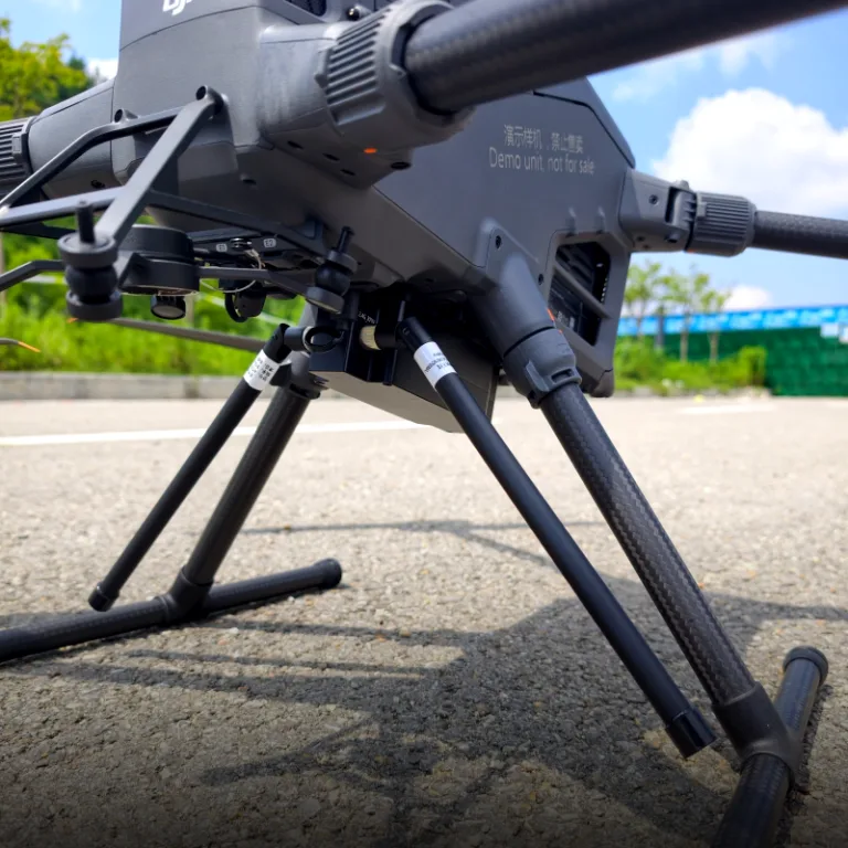
SkyEye serves as the aerial detection node within Tiruo Innovation’s low-altitude security system. Mounted on industrial-grade UAVs such as the DJI Matrice 400 RTK, it leverages an aerial vantage point to bypass ground obstructions and deliver RemoteID detection coverage up to 10 kilometers. Capable of multi-target tracking (≥20 aircraft), it functions as the airborne component of an integrated air-ground three-dimensional prevention and control system. Data is transmitted to the remote controller via the DJI OcuSync video transmission link, displayed in real time through a DJI Pilot 2 plugin, and relayed to the SaaS cloud platform via the remote controller’s cellular network.
Core Specifications
| Parameters | Specifications | Description |
|---|---|---|
| Detection Range | ≥10km (Open Environment) | 10km Aerial RemoteID Detection Radius |
| Simultaneous Detection | ≥20 UAVs | Simultaneously track at least 20 UAVs |
| Weight | ≤350g | Lightweight mounting design under 350 grams |
| Compatible UAV Models | DJI Matrice 400 RTK | Powered via DJI Matrice 400 RTK E-Port V2 |
| Power Supply Mode | UAV Power Supply (E-Port V2) / Tethered Power Supply Supported | Direct power supply from the mounted UAV / Tethered power supply |
| Protection Rating | IP43 | IP43 Protection Class |
| Main Unit Dimensions | 150mm × 55mm × 45mm | Compact form factor without interfering with gimbal operation |
| Operating Temperature | -20°C ~ 50°C | Wide temperature range for high-altitude operation |
| Data Link | SkyEye → OcuSync → DJI Remote Controller → Cellular Network → MQTT 5.0 → SaaS Cloud Platform | Must be used with the DJI Pilot 2 plugin; cannot connect to the cloud independently |
Detailed Functional Introduction
Wide-Range Aerial Scanning
- 10-kilometer detection radius, exceeding the 5-kilometer limit of ground-based equipment
- The aerial perspective avoids obstructions from terrain, buildings and vegetation to deliver horizon-level detection.
- Simultaneously track at least 20 UAVs, suitable for large-scale events and multi-UAV formation scenarios
Plug-and-play Mounting
- Supports direct power supply via DJI Matrice 400 RTK E-Port V2 interface and works with tethered power supply
- Quick-release structure, installation and disassembly completed within 3 minutes
- Rearward center-of-gravity design to guarantee flight stability and normal gimbal operation
- RF antennas extend from both sides to avoid airframe obstruction and guarantee signal reception quality
Real-time display via DJI Pilot 2 plugin
- Runs on DJI RC Plus 2 remote controller and works in coordination with DJI Pilot App
- Four-zone layout: Status Bar + Overview List + Detail Panel + Operation Buttons
- Supports simultaneous display of no less than 20 aircraft; target switching response time ≤ 200ms
- Multi-target tracks displayed on a single screen with unique blue color coding; supports timeline playback for historical review
Mission Log & Data Export
- Automatically record mission start and end time, aircraft list, track point sequences and signal strength variations
- Supports export in CSV, Excel and TXT formats
- Supports date filtering and playback of historical missions
Fused RID/DID Identification
- Automatic association and merging of Remote ID and detected identities
- Prioritize displaying complete information; auto-fill missing fields
- Association accuracy ≥ 95%
Internationalization Support
- Supports switching between Chinese and English interfaces
- Overseas version automatically adapts to Google Maps / OpenStreetMap
- Date format automatically adjusted according to regional conventions
Data Flow
Airborne Terminal · SkyEye (YunScan-Air)
Aerial overhead view, 10km coverage radius, tracks ≥20 aircraft simultaneously>
OcuSync Video Transmission
DJI RC Plus 2 Remote Controller
Cellular Network
(MQTT protocol transmission to cloud)
SaaS Cloud Platform
Aggregates all SkyEye detection data, provides unified situational awareness, alarm management and post-event review
Key Rules
- The DJI Pilot 2 Plugin only displays data captured by the SkyEye airborne terminal; it cannot show data from fixed sentry terminals or handheld LingSearch terminals.
- SkyEye data is transmitted to the remote controller via the OcuSync link, then uploaded to the SaaS cloud platform through the remote controller’s cellular network.
- SkyEye cannot connect to the cloud independently; it must be paired with the DJI Pilot 2 Plugin.
Role in the Three-Terminal Collaborative System
| Core Role | Coverage Mode | Final Data Destination |
|---|---|---|
| Wide-range rapid scanning | Integrated air-ground detection with obstacle penetration capability | DJI Pilot 2 Plugin → SaaS Cloud Platform |
- Urban high-rise districts: Fixed ground terminals are blocked by buildings; SkyEye eliminates blind zones via overhead downward scanning after takeoff
- Mountainous/hilly terrain: Ground devices are obstructed by landforms; SkyEye leverages altitude to cover valley reverse slopes
- Pre-event wide-area screening: Rapidly scans a 10km radius before large-scale events to verify airspace safety
- Obstacle-crossing tracking: Maintains continuous pursuit of illegal drones even after targets enter ground detection blind zones
- Fixed Sentry Terminal: Delivers permanent base coverage; data directly uploaded to the SaaS platform
- Handheld LingSearch Terminal: Bluetooth → Mobile App → 4G/5G → MQTT for cloud upload
- Airborne SkyEye Terminal: OcuSync → DJI Remote Controller → Cellular Network → MQTT for cloud upload
- Data from all three terminal types is fused on the SaaS cloud platform, enabling multi-source data integration, unified alarm dispatch and centralized post-event review.
Typical Application Scenarios
| Scenario | Operation Mode | Core Value |
|---|---|---|
| Pre-event airspace screening for large-scale activities | Take off to scan the full 10km radius before events | Rapidly assess airspace safety status |
| Security monitoring for urban high-rise zones | Deploy drone to take aerial overhead shots | Bypass building obstructions to detect illegal drones hidden in ground blind zones |
| Mountain & border patrol inspection | Mount on inspection drones for ridge-line flights | Cover valleys, reverse slopes and other ground detection dead zones |
| Illegal drone pursuit | Launch drone to track targets after detection | Maintain continuous tracking even if targets enter ground blind areas |
| Multi-drone formation monitoring | Simultaneously track ≥20 unmanned aircraft | Suitable for dense airspace scenarios such as large events and drone light shows |
Compliance Standards
- National Standard of China: GB 42590-2023 Safety Requirements for Civil Unmanned Aircraft Systems
- EU Standard: ASD-STAN prEN 4709-002
- US Standard: ASTM F3411
- Communication Protocols: OcuSync + MQTT 5.0
- Deployment Options: Supports private deployment for fully controllable data security